Geocentric coordinates
Okay kiddo, so you know how we live on Earth, right? And Earth is pretty big, so sometimes scientists or astronauts need to know exactly where they are, like on a map. That’s where geocentric coordinates come in!
Basically, geocentric means that we’re talking about Earth as the center of things. So the coordinates are a way to measure where something is on Earth. It’s like a big game of “X marks the spot” but with lots of numbers and letters.
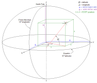
There are two main types of geocentric coordinates: longitude and latitude. Longitude measures how far east or west something is from a special line called the Prime Meridian, which runs through Greenwich, England. Latitude measures how far north or south something is from the Equator, which is an imaginary line that circles Earth horizontally.
To figure out a geocentric coordinate, you need to use both longitude and latitude together. Think of it like playing a game of Battleship: you say the letter and the number to find the spot on the board. So if you say 40° N and 75° W, you’re talking about a specific spot on Earth.
Geocentric coordinates can be really helpful for all kinds of things, like navigation, mapping, and even studying Earth’s climate or atmosphere. It’s like a giant treasure hunt with invisible lines and numbers!
Basically, geocentric means that we’re talking about Earth as the center of things. So the coordinates are a way to measure where something is on Earth. It’s like a big game of “X marks the spot” but with lots of numbers and letters.
There are two main types of geocentric coordinates: longitude and latitude. Longitude measures how far east or west something is from a special line called the Prime Meridian, which runs through Greenwich, England. Latitude measures how far north or south something is from the Equator, which is an imaginary line that circles Earth horizontally.
To figure out a geocentric coordinate, you need to use both longitude and latitude together. Think of it like playing a game of Battleship: you say the letter and the number to find the spot on the board. So if you say 40° N and 75° W, you’re talking about a specific spot on Earth.
Geocentric coordinates can be really helpful for all kinds of things, like navigation, mapping, and even studying Earth’s climate or atmosphere. It’s like a giant treasure hunt with invisible lines and numbers!
Related topics others have asked about: