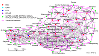
Geodetic control network

A geodetic control network is like a giant puzzle of dots on the earth's surface. These dots, called control points, help people figure out where things are in the world. The control points are carefully measured and marked with special equipment so that they are accurate. Imagine drawing a treasure map and putting an X where the treasure is. The control points are like those X's on the treasure map, except instead of marking treasure, they are marking places on the earth.
These control points are important because they help people who need to measure things like distances, heights or depths, or to make maps. For example, if you took a picture of a mountain and wanted to know how tall it was, you could use the control points to figure it out.
People who use the geodetic control network make sure to keep it up to date, meaning they add new control points or update old ones, so that the information stays accurate. It's kind of like replacing puzzle pieces that have become worn out, so the puzzle stays complete and accurate for everyone to use.
In summary, a geodetic control network is a group of carefully measured and marked dots on the earth's surface that help people figure out where things are located and make accurate measurements or maps. They are like puzzle pieces that must always be kept up to date to be helpful.
Related topics others have asked about:
