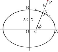
Geodetic coordinates

Imagine playing a game of hide and seek, but instead of using a house or a room to hide, you use the whole planet Earth! Geodetic coordinates are the special way we use to tell someone where to hide or find something in the planet.
You know how when you want to find your house, you tell someone your address, like "123 Main Street"? Geodetic coordinates are like an address, but for any point on Earth. Instead of using a street name and number, we use special numbers called latitude and longitude.
Latitude is like an imaginary line that goes around the Earth like a belt. It measures how far up and down you are from the middle of the Earth. The closer you are to the Equator, the smaller your latitude number is. For example, at the Equator, the latitude is 0 degrees, but at the North Pole, the latitude is 90 degrees north.
Longitude is like another imaginary line that goes around the Earth like a big circle. It measures how far east or west you are from a special location called the Prime Meridian. The Prime Meridian goes through Greenwich, a town in England. The closer you are to the Prime Meridian, the smaller your longitude number is. For example, if you are at the Prime Meridian itself, your longitude is 0 degrees, but if you're on the opposite side of the planet, your longitude is 180 degrees.
So, if you wanted to tell someone where the Great Pyramids of Egypt are, you could use its geodetic coordinates: 29.9792 degrees north latitude, 31.1342 degrees east longitude. That's like telling someone the address of the Great Pyramids!
Related topics others have asked about:
