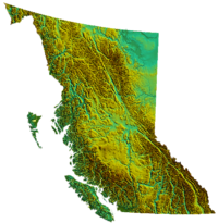
Geography of British Columbia

Hello there! Do you know what geography means? It means studying the land, the water, the weather, and everything that makes up our planet. Today, let's talk about the geography of British Columbia.
British Columbia is a big province in Canada and it's located on the west coast. There are many different things that make up the geography of British Columbia.
Mountains: First of all, let's talk about the mountains. British Columbia is home to many mountain ranges including the Coast Mountains, the Rockies, and the Columbia Mountains. Mountains are very tall and they are made of rocks and dirt. They can also have snow on the top which is really beautiful.
Forests: British Columbia is also known for its forests. Trees grow very well in BC because they have a lot of rain and a nice climate. Trees are very important to our planet because they give us oxygen to breathe. Some of the trees in BC are very old and tall. BC also has a lot of animals that live in the forests like bears, wolves, and beavers.
Water: There is a lot of water in British Columbia. There are lakes, rivers, and even the ocean. The Pacific Ocean is on the west side of the province and it's very big. Rivers are like long streams of water that flow through the land and they can be used for fishing or for rafting. Lakes are also very important because they can provide water for people and animals.
Climate: The climate in British Columbia is different depending on where you are. The coastal regions are usually very mild and rainy, whereas the interior parts of the province can have very cold winters and hot summers.
In summary, British Columbia has many mountains, forests, bodies of water, and varying climates. It's a beautiful place and there is still so much more to explore and discover!
