Geography of Chile
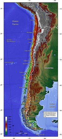
Chile is a country located in South America, kind of like how you live in your house in your neighborhood. It's a very long and thin country, almost like a noodle! This is because it stretches along the western coast of South America, from the top to the bottom.
Chile has some really tall mountains called the Andes, which are like big bumps in the ground but way bigger than any bump you might see on your street. These mountains go all the way down the country, like a long line of bumps. And did you know that there's a really big volcano in Chile called Villarrica? It's super cool to look at, but we have to be careful around it because it can be dangerous!
Chile also has a really long coast that stretches along the Pacific Ocean, which is like a big bathtub but so big you can't see the other side. The coast has lots of beaches and cliffs, and sometimes there are big waves that surfers love to ride. There are also lots of fish and other sea creatures living in the ocean near Chile.
In the northern part of Chile, it's really hot and dry, almost like a desert. There are sand dunes and cacti, and sometimes it doesn't rain for a very long time. But in the southern part, it's much cooler and there is more rain, almost like a big forest. There are lots of tall trees and small animals like birds and squirrels.
Chile has many different cities with different things to see and do. In the capital city, Santiago, there are lots of buildings and museums to visit. In Valparaiso, there are colorful houses and a big port. And in Easter Island, which is part of Chile, there are huge statues called Moai that are very mysterious and interesting.
So you see, Chile is a very long and interesting country with lots of different things to discover!
Related topics others have asked about: