Surface weather analysis
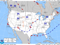
Ok kiddo, imagine you are looking at a big map of the world. On that map, you see lots of lines that look like wiggly snakes. These lines are called isobars. Think of them as lines that connect places on the map where the air pressure is the same. Some places have more air pressure and some places have less air pressure.
Now, let's think about how this affects our weather. Air always flows from high pressure to low pressure. So, if you have one place on the map with high pressure and another place with low pressure, air will flow from the high pressure area to the low pressure area. This movement of air is what creates wind.
But wind isn't the only thing that affects our weather. We also have things like warm and cold fronts. A warm front is where warmer air moves into an area that was previously cooler. A cold front is where cooler air moves into an area that was previously warmer. When these fronts meet, they can create some pretty interesting weather, like thunderstorms or even tornadoes.
So, on the surface weather map, you'll see all sorts of symbols that represent different types of weather. You might see a little cloud symbol where it's going to be cloudy, or a lightning bolt where there's going to be a thunderstorm. You might also see symbols that show which direction the wind is blowing and how fast it's going.
All of these symbols and lines help meteorologists (the people who study the weather) figure out what the weather is going to be like in different parts of the world. Pretty cool, huh?
Related topics others have asked about: