Topographic profile
A topographic profile is like a picture that shows us what the land looks like from one side to the other. Imagine you have a birthday cake in front of you, and you want to see what it looks like from one side. You could cut it in half and look at the cut side - that's like a topographic profile!
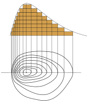
But instead of a cake, we're looking at the land. To make a topographic profile, we take a line and draw it across a map. Then, we draw a picture of what the land looks like under that line. We draw all the hills, valleys, and mountains, and how high or low they are.
It's kind of like drawing a picture of a roller coaster. We draw how high it goes up and how low it dips down. That way, we can see what the ride would feel like if we were on it.
Topographic profiles are important because they help us understand how the land changes. We can see where the high points and low points are, and how steep the slopes are. Scientists use topographic profiles to learn about the Earth's surface and how it changes over time.
Related topics others have asked about: