Cartogram
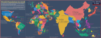
A cartogram is a map where instead of drawing shapes of countries or states and labeling them, the area of each place is changed to show how much of something is in it. For example, if you wanted to show how many people live in each country, the countries with more people would be bigger than the countries with fewer people, even though their actual shape might be different.
Related topics others have asked about: