Cartographic labeling
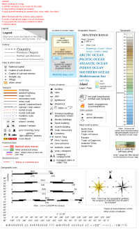
Cartographic labeling is like giving names to things on a map so that we can understand what they are. It's like when you draw a picture of your family and label each person with their name. When we draw a map, we also add names to the different places.
For example, if we draw a map of our house, we can label the different rooms like the kitchen, bedroom, bathroom, and living room. When we draw a map of a city or a country, we can label the different cities, rivers, mountains, and other landmarks.
When we label things on a map, we need to make sure that the labels are easy to understand and read. We also need to make sure that they don't cover up important information on the map. This can be tricky, so cartographers (the people who make maps) often use different techniques to make sure the labeling is clear and easy to read.
Cartographic labeling is important because it helps us navigate and understand the world around us. When we know where things are and what they are called, we can explore new places and learn about different parts of the world.
Related topics others have asked about: