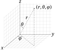
Coordinate transformation

Alright kiddo, so let's say you have two maps of the same place, but they look different. One map might be zoomed in really close, while the other one might show a bigger area. That means the two maps have different scales, and they don't match up perfectly.
Now, imagine you want to find a specific point on both maps - like your house, for example. On one map, your house is in one spot, but on the other map, it's in a completely different spot! That's because the two maps are using different coordinates to describe where things are.
So, coordinate transformation is like taking one map and figuring out how to convert the coordinates on that map so they match up with the coordinates on the other map. It's kind of like a puzzle - you have to figure out how to shift, rotate, and scale the first map so that it lines up perfectly with the second map.
Once you've done that, you can use the same coordinates on both maps to find your house or any other point you're looking for. And that makes it way easier to navigate, whether you're trying to find your way around a new city or chart a course through space!
Related topics others have asked about:
