Geography of Barbados

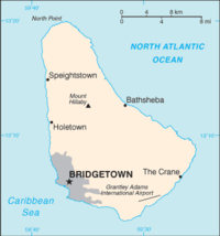
Barbados is a small island in the Caribbean Sea. It is shaped like a pear or a teardrop. In the south and west, the island has flat areas and sandy beaches. In the east and north, the land is more rocky and there are cliffs along the coast.
Barbados has warm weather all year round because it is close to the equator. It can be really hot and sunny during the day, but it can also get rainy and humid. When it rains, the island gets lush and green.
The island has a ring road that goes all the way around it. The capital city, Bridgetown, is on the southwestern side of the island. It's where most of the businesses and government offices are located.
Barbados is also known for its coral reefs. Coral reefs are like underwater cities made up of tiny creatures called polyps. These polyps work together to create a hard skeleton which eventually creates a whole reef. Barbados has many of these reefs which attract tourists who like to swim and snorkel among the colorful fish and corals.
Overall, Barbados is a beautiful island with a mix of flat and rocky areas, warm weather, and lots of coral reefs.
Related topics others have asked about:
