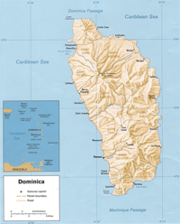
Geography of Dominica

Okay kiddo, let's learn about the geography of Dominica! Dominica is a small island country in the Caribbean Sea. It's shaped like a banana!
Dominica is full of mountains and hills. This means that the land is very bumpy and not flat like a pancake. The highest point of the island is called Morne Diablotins, which is about 4,747 feet high! That's even taller than some airplanes fly!
Dominica is also famous for its many rivers. These rivers run down the mountains and hills and into the ocean. There are over 360 rivers on this little island!
The climate in Dominica is tropical, which means it's usually very warm and humid. The island also gets a lot of rain, which helps all of the plants grow. Speaking of plants, Dominica is often called the "Nature Island" because it's full of lush forests, exotic flowers, and fruit trees.
Finally, let's talk about beaches! Dominica has some beautiful beaches with soft white sand and clear blue water. However, the island is not known just for beaches but for diving as well. There are many special things to see underwater such as colorful fish, octopuses, and shipwrecks!
That's pretty much the geography of Dominica, little one. Remember, it's a bumpy island full of mountains and rivers with a tropical climate, lots of plants, and beautiful beaches.
