Geography of Ireland
Alright kiddo, so let's talk about the geography of Ireland.
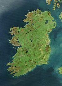
First, imagine a giant green island in the middle of the Atlantic Ocean with lots of hills, mountains, lakes, and rivers. That's Ireland, and it's divided into four provinces: Ulster, Connacht, Leinster, and Munster.
If you look at a map of Ireland, you'll notice that it's shaped like a teddy bear. The northern part is called Northern Ireland, and it's part of the United Kingdom, while the rest of the island is a country called the Republic of Ireland.
Ireland has many mountains, but the highest one is called Carrauntoohil and is located in County Kerry, which is part of Munster. These mountains have created beautiful valleys and hillsides with fertile soil, which is why Ireland is known as the Emerald Isle.
There are also many rivers and lakes in Ireland, which help to make it a very green and fresh place to live. The River Shannon is the longest river in Ireland, and it flows through the central part of the country. Lakes like Lough Corrib in Connacht and Lough Neagh in Ulster are popular for fishing and other water activities.
Finally, Ireland has a long coastline that touches the Atlantic Ocean. This coastline is made up of rocky cliffs, sandy beaches, and lots of small islands. Some of the most famous coastal sights include the Cliffs of Moher in Munster and the Giant's Causeway in Northern Ireland.
Overall, Ireland has a diverse and beautiful geography that makes it a unique and special place in the world.
Related topics others have asked about: