Interferometric synthetic-aperture radar

Interferometric synthetic-aperture radar (InSAR) is kind of like magic eyes. You know magic eyes? They are pictures that are all blurry and confusing until you cross your eyes just right and then suddenly a 3D image appears. InSAR is like that, but instead of a picture, it's a way to look at the earth's surface in 3D.
You might have seen pictures from satellites or airplanes that show what the earth looks like from above. InSAR is a way to make those pictures even more detailed by measuring the distance between the satellite or airplane and the surface of the earth.
Here's how it works. InSAR sends out a signal, kind of like a ping. This ping travels down to the ground and then it bounces back up to the satellite. The satellite measures the time it took for the ping to travel down to the ground and back up to the satellite. Based on the time it took, the satellite can figure out how far away the ground is.
Now, InSAR does this not just once, but thousands of times. It sends out pings in all different directions, so it can figure out how far away the ground is at different points. This gives us a really detailed picture of the shape of the earth's surface.
But there's one problem. The earth is always moving, which means that things on the ground are always changing their shape and position. So the detailed picture we get from InSAR might not be accurate for very long.
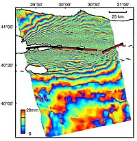
That's where the "interferometric" part of InSAR comes in. Interferometry means that we take two different images at different times and compare them to each other. By doing this, we can see how the ground has changed shape and moved between those two times.
We take one image at one time, and then another image at a later time. When we combine those two images, we can see which parts of the surface have moved and how much they've moved. This is really helpful for things like monitoring earthquakes, where the ground can move a lot in a short period of time.
In summary, InSAR is a trick to measure the distance between a satellite and the earth's surface in thousands of directions. By taking pictures over time and comparing them, we can see how the ground is changing and moving. It's like magic eyes for the earth!
Related topics others have asked about:
