Maritime boundary

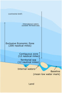
Maritime boundary is the imaginary line that separates the water area of two countries that are next to each other. Just like on a playground when you and your friend play together, there is a line that you decide not to cross. This is because you both agree that each of you has a certain area that belongs to you.
In the same way, countries have borders that separate their land area, but they also have borders that separate their water area, and this is what we call a maritime boundary. It helps countries know exactly where their jurisdiction begins and ends in the ocean, so they can decide what they are allowed to do in this specific area. For example, they can control who can fish, drill for oil or gas, or even sail their ships in these waters.
The tricky part is that the ocean is one big body of water, and it is not always easy to know where one country's water area ends and another's begins. This is why countries sometimes have disagreements over this imaginary line, and they need to negotiate and come to an agreement through treaties and international law.
Related topics others have asked about:
Arctic Cooperation and Politics,
Beagle Channel Arbitration,
Exclusive Economic Zone,
International Court of Justice,
International Seabed Authority,
Jurisdiction of the International Court of Justice,
Permanent Court of Arbitration,
South Pacific Applied Geoscience Commission,
Territorial claims in the Arctic
