Meridian (geography)
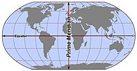
A meridian is an imaginary line that goes from the North Pole to the South Pole on a map or globe. It's like a big long stripe that is used to help us understand where things are in the world. It divides the earth into eastern and western halves, kind of like cutting a cake into two pieces. The meridian that is used as the starting point is called the Prime Meridian, which passes through Greenwich, England. Other meridians are numbered from the Prime Meridian and are used to pinpoint the location of places around the world. So, if you ever want to find out where you are on a map, find the meridian that goes through your location and you'll know which part of the world you're in.
Related topics others have asked about: