Stereographic projection in cartography
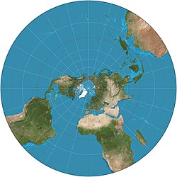
Imagine you are drawing a map of the world. Usually, the way we draw maps makes the world look a bit flat, but in reality, the Earth is round like a ball. It's hard to take a round thing and draw it on a flat piece of paper without distorting it. That's where stereographic projection comes in!
Stereographic projection is like taking a picture of the Earth from outer space and then projecting that picture onto a flat map. But instead of just flattening the whole picture, stereographic projection keeps some parts of the picture "round" and squishes other parts down.
To do this, we start with a globe that has all the countries and oceans on it. Then, we imagine a flat piece of paper that we want to project our map onto. We place that paper on a special point on the globe called the "south pole" (which is the bottom of the globe).
Now, we pretend that we have a flashlight shining from the very center of the Earth, straight up through the North Pole and out into space. The light shoots straight up and touches the flat piece of paper at just one point. This is called the point of projection.
Next, we take the continents and oceans from the globe and project them onto the flat piece of paper. But instead of just stretching them and squishing them to fit, we do something special. We draw imaginary lines connecting the point of projection to every point on the globe.
These lines are like rays of light shooting out from the center of the Earth. We can think of them as a bunch of very long, very thin triangles that start at the point of projection and go all the way to the edge of the globe.
Then, we take each point on the globe and find the place where its "ray of light" intersects with the flat piece of paper. This is where we draw that point on the map.
But here's the catch: as we get further from the center of the globe, our rays of light get closer and closer to being parallel to each other. Eventually, they are like train tracks that never meet (no matter how far you extend them). So, when we try to project the points near the edge of the globe onto the flat piece of paper, they get very squished and distorted. This is why Greenland looks so huge on some maps – it's because it's near the edge of the globe and gets stretched out a lot during stereographic projection.
Overall, stereographic projection is a cool way to make maps that look more similar to the round Earth, but it has some downsides too. Different types of projections can be better suited for different purposes, so cartographers have to choose carefully which projection they use depending on what they want to do with the map.