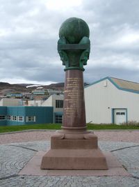
Struve Geodetic Arc

Okay, kiddo. Have you ever seen a big circle that is drawn on a map or a globe? It's called an arc. Now, the Struve Geodetic Arc is a very special arc that goes through 10 countries in Europe, from the Arctic Ocean to the Black Sea. It was first measured by a man named Friedrich Georg Wilhelm von Struve about 200 years ago.
So, why is this arc so special? Well, it helped people figure out the size and shape of the Earth! Struve and his team used fancy instruments to measure the angles and distances between points along the arc. They did this because they wanted to know if the Earth was round like a ball or if it was shaped differently.
Now, measuring an arc is not an easy thing to do. It requires a lot of patience, precision and hard work. Struve and his team had to camp out in the wilderness for months at a time, battling cold, wind and rain. They had to climb mountains, cross rivers, and fight off mosquitoes and other bugs.
But all their effort paid off. By measuring the Struve Geodetic Arc, they were able to prove that the Earth was indeed a round ball. They were also able to calculate its size and shape with astonishing accuracy. This information was used to create more accurate maps and to help ships and planes navigate the Earth.
So, in short, the Struve Geodetic Arc is a very special arc that helped people figure out the size and shape of the Earth. It was measured by a man named Struve and his team using fancy instruments about 200 years ago. And that's why it is still important today!
Related topics others have asked about:
