Geographic coordinates
Geographic coordinates are like giving someone directions to find a spot on a big map!
The Earth is like a big ball and it’s divided into different sections (kind of like slices of pizza) that are called latitude and longitude lines. These lines help us figure out exactly where we are on the Earth.
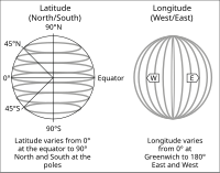
Latitude lines are the ones that run from east to west, and they’re measured in degrees. They’re kind of like stairs, with each step being one degree. They tell us how far north or south we are from the equator (which is like the middle of the Earth).
Longitude lines are the ones that run from north to south, and they’re also measured in degrees. They’re kind of like slices of cake, with each slice being one degree. They tell us how far east or west we are from the Prime Meridian (which is like the middle point between the North Pole and South Pole).
So when you hear someone give geographic coordinates, they’re telling you how many degrees north or south they are (latitude) and how many degrees east or west they are (longitude). It’s like giving someone an exact spot on the map!
The Earth is like a big ball and it’s divided into different sections (kind of like slices of pizza) that are called latitude and longitude lines. These lines help us figure out exactly where we are on the Earth.
Latitude lines are the ones that run from east to west, and they’re measured in degrees. They’re kind of like stairs, with each step being one degree. They tell us how far north or south we are from the equator (which is like the middle of the Earth).
Longitude lines are the ones that run from north to south, and they’re also measured in degrees. They’re kind of like slices of cake, with each slice being one degree. They tell us how far east or west we are from the Prime Meridian (which is like the middle point between the North Pole and South Pole).
So when you hear someone give geographic coordinates, they’re telling you how many degrees north or south they are (latitude) and how many degrees east or west they are (longitude). It’s like giving someone an exact spot on the map!
Related topics others have asked about: