Geographic information system
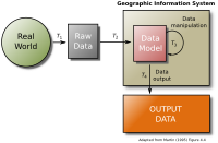
A geographic information system (or GIS) is a computer system that lets us map and keep track of things in a certain area. When you look at a map of your city, that map is made with GIS. It can show things like roads, parks, buildings, and other important places like hospitals. GIS also helps us keep track of things like the population of a city, which businesses are in what area, and where different kinds of plants and animals live. GIS helps us better understand and plan for our environment.
Related topics others have asked about: