Geography of Manitoba

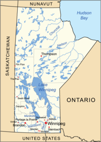
Manitoba is a big place in Canada, sort of like a giant sandbox. It has borders with Saskatchewan to the west, Ontario to the east, and the U.S. states of North Dakota and Minnesota to the south. In the far north, it also borders the Northwest Territories and Nunavut.
Manitoba is mostly flat and covered in grassy fields, like a big lawn. This is called the prairie, and it's famous for its wheat and other grains that grow here. There are also lots of rivers and lakes, like big puddles of water, which are important for fishing, recreation, and transportation.
In the south of Manitoba, there's a big city called Winnipeg, which is like a giant playground for people. It has lots of buildings, roads, and even an airport, where people can come and go to other parts of Canada or the world.
Up in the north of Manitoba, it's a little different. It's very cold, and there's a lot of snow and ice for a lot of the year. This is the home of some First Nations and Indigenous peoples, who have lived there for thousands of years. They have their own languages, cultures, and traditions, and they are an important part of Manitoba's geography and history.
Overall, Manitoba is a big, diverse place with lots of different people, cultures, and natural features. Whether you like playing in the sand, swimming in the water, or exploring new places, there's always something to discover in Manitoba.
Related topics others have asked about:
