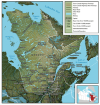
Geography of Quebec

Hey there, little one! Today, we're going to learn about the geography of Quebec, which is a province in Canada. Quebec is a really big place with lots of different things in it, so let's break it down into simple parts!
First, let's talk about land and water. Quebec has lots of both! It's bordered by the Hudson Bay and James Bay to the north, the Gulf of Saint Lawrence to the east, and the United States to the south. And in the middle of Quebec, there are lots of rivers and lakes, including the Saint Lawrence River and the Great Lakes.
Now, let's talk about what the land in Quebec looks like. There are three main regions: the Canadian Shield, the St. Lawrence Lowlands, and the Appalachian Mountains. The Canadian Shield covers most of northern Quebec and is made up of rocky terrain. The St. Lawrence Lowlands are in the south and are flatter, with lots of farmland and cities like Montreal and Quebec City. And in the eastern part of Quebec, there are the Appalachian Mountains, which are smaller than other mountain ranges but still pretty cool.
Finally, let's look at the climate in Quebec. Because it's such a big place, it actually has different climates in different regions! In the south, where the St. Lawrence Lowlands are, the summers are warm and humid, while the winters can be really cold with lots of snow. In the north, it's even colder and there's a lot more snow. And in the mountains, it's cooler and there's even some snow in the summer!
So, in summary, Quebec is a province in Canada with lots of land and water, including the Canadian Shield, St. Lawrence Lowlands, and Appalachian Mountains. It has different climates in different regions, with warm summers and cold winters in the south, and very cold and snowy winters in the north.
Related topics others have asked about:
