Geospatial topology
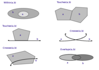
Geospatial topology is like putting a puzzle together with maps. It helps us understand how different things are connected to each other, like two cities that are connected by a road or a river that flows through different countries.
Imagine you have a map with different colored dots on it. Each dot represents something unique, like a city or a house or a tree. Now, we want to know how these dots or items are related to each other. To do this, geospatial topology helps us create a network or a framework that can connect these dots, and show how they are related.
For example, imagine a map of a city, and you want to know how different streets are connected to each other. Geospatial topology can help us create a network showing the different streets and highways, the intersections, and the one-way roads. This helps us understand how to get from one place to another, like from your house to school.
Overall, geospatial topology helps us create a visual representation that shows how different things are connected to each other on a map. It is like putting together a puzzle or creating a map legend that helps us understand the connections between different items on a map.
Related topics others have asked about: