Interferometric synthetic aperture radar

Interferometric synthetic aperture radar, or InSAR for short, is a special type of radar that helps scientists make pictures of things from space. A normal camera takes pictures of things by using light, but InSAR doesn't use light, it uses special radar waves.
Radar waves are a bit like invisible bouncy balls that can travel through the air and bounce off things like mountains, buildings, and other objects on Earth's surface. To make a picture with InSAR, scientists first send out a bunch of radar waves and wait for them to bounce back. They do this many, many times to get lots of measurements of the same area.
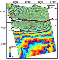
Once they have all these measurements, they can use them to make a 3D picture of Earth's surface. This is where InSAR gets really clever. By comparing two or more pictures taken at different times, scientists can see if the ground has moved. If there's been an earthquake, for example, they would be able to see where the ground has shifted.
To see this movement, InSAR creates something called an "interference pattern." This is a bit like when two sets of ripples from two rocks in a pond meet and overlap – they create a crazy pattern of big and small ripples. InSAR does the same thing with radar waves, creating an interference pattern that tells scientists where the ground has moved.
Overall, InSAR is a really cool way for scientists to make pictures of Earth's surface and see how it's changing over time.
Related topics others have asked about:
