Lunar distance (navigation)
So you know how when we walk, we can tell where we are going by looking around and figuring out landmarks, right? Well, imagine you are in a boat sailing on the ocean and you can’t see any landmarks - no trees, no buildings, nothing! How do you know where you are going or where you are?
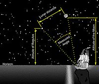
That’s where lunar distance comes in! We can use the moon to help figure out how far we are from our destination. First, we use a special tool called a sextant to measure the angle between the moon and the horizon. This tells us how high the moon is in the sky.
Next, we compare that measurement to a table of numbers that tells us what the moon’s angle should be if we were in a certain spot on the earth. By comparing our measurement to the table, we can figure out how far away we are from that spot on the earth!
So imagine you are a pirate sailing the seven seas. You see the moon in the sky and measure its angle with your sextant. Then you look at your table and see that the moon’s angle should be a certain number if you are in the Caribbean. If the angle you measured matches the table, you know that you are in the right place. If the angle is off, you can keep sailing until the numbers match up - then you know you’re where you’re supposed to be!
And that, my little matey, is the magic of lunar distance navigation!
Related topics others have asked about: