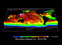
Ocean surface topography

Have you ever been swimming in a pool and noticed that the water level isn't the same at every spot? Some areas are higher and others are lower. This here is just like how the ocean has high and low spots too.
Ocean surface topography is a way of looking at the ocean and measuring how high or low different spots on its surface are. This helps scientists understand how the ocean moves, how currents flow, and even how climate changes can affect the ocean.
We use special tools called satellites to measure the surface topography of the ocean. These satellites send out radar waves to the ocean's surface, which bounce back and tell us how high or low the water is. This is kind of like when you shout into a mountain and hear your voice echo back.
With all the information we get from these satellites, we can create maps that show us how the ocean's surface varies around the world. This is super helpful because we can use this knowledge to predict things like weather patterns, sea levels, and even to help ships navigate safely through the ocean.
So, just like how the surface of a pool can tell you something about the water inside of it, ocean surface topography helps scientists learn more about the ocean and the many things that live in it.
Related topics others have asked about:
