Physical terrain model
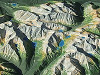
Hey there kiddo! Do you want to learn about physical terrain models? Well, a physical terrain model is a tiny little landscape that people make to help them understand what a big landscape looks like. Think of it like a miniature version of a mountain, hill, or even a whole city!
It's like playing with toy cars but instead of cars, we have a miniature version of a mountain. These models can be made out of different materials like plastic, clay, or even paper. People can look at these models and see what the real place would look like from above.
Sometimes, people make these models so they know what the environment looks like before they go there. Maybe if someone wanted to go on a hike, they could study the model to see what the trail would be like. It's like looking at a map but a lot more fun because you can touch and move the model around.
Physical terrain models can also be used for lots of other things. For example, engineers might use them to help plan a city, or archaeologists might use them to help understand what an ancient city used to look like.
So there you have it, a physical terrain model is a tiny little landscape that we make to help us understand big landscapes. It's like playing with toy cars, but instead of cars, it's a miniature version of a mountain or city that we can touch and move around to learn more about the real place.
Related topics others have asked about: