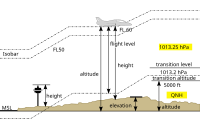
Topographic elevation

Topographic elevation is a way of measuring how high or low different places on earth are compared to one another. Think of it like a big playground with hills and valleys. Some parts of the playground are higher than others, right?
Now imagine if we measured how high each part of the playground was using a special tool called a level. This tool can tell us if one part of the playground is higher or lower than another part.
That's kind of what topographic elevation is - it's a fancy way of measuring how high or low different parts of the earth are in relation to each other. Scientists use special tools to make these measurements, and they end up with a colorful map that shows all the different elevations.
So if you were looking at a topographic map of your town, you might see that the hills and mountains are the highest parts, while the valleys and lowlands are the lowest parts. It's like a big 3D map that shows us how the land rises and falls across the earth.
Related topics others have asked about:
