Baseline (sea)

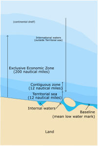
A baseline (sea) is like drawing a line in the sand at the edge of the beach so we know where the water begins. Except for countries, it's not just any line, it's a special line that goes all around the country's coast. The line is drawn at the lowest point of the low tide that happens over a period of time (usually 18-24 years). This line is important because it is used to determine the country's territory in the ocean. So, everything within the line belongs to the country and everything beyond it belongs to other countries or is considered international waters. It's like when you draw a line between your toys and your friend's toys, except this line is drawn in the sea and it helps countries know which part of the ocean is their toy.
Related topics others have asked about:
