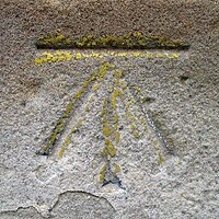
Benchmark (surveying)

Okay kiddo, do you know what a ruler is? It's a tool people use to measure things like the length of a piece of paper or the height of a toy.
But when people need to measure something really big, like a field or a whole city, they need something bigger and more precise than a ruler. That's where benchmarks come in!
A benchmark is basically a really specific and carefully measured spot on the ground that surveyors use as a reference point. They measure the distance from the benchmark to other spots they want to measure, like corners of buildings or other landmarks.
Surveyors use special equipment to determine the exact location of the benchmark, like GPS or special instruments called levels. Once they find the exact spot they need for the benchmark, they make a little marker there so they can always find it again later. Sometimes the marker is a little metal disk embedded into the ground or a concrete pedestal, and other times it may be something hanging from a tree or mounted on a wall.
Later on, if someone needs to measure something in the same area, they can use the benchmark as a reference point. This makes sure that everyone is working from the same starting point and all the measurements are accurate.
So the benchmark is like a special spot that surveyors use to make sure they are measuring things accurately, and it helps them create maps and plans for all kinds of things. Pretty neat, huh?
Related topics others have asked about:
