Geography of Iran
Okay, so imagine there is a big country called Iran. It's really far away from where we are right now. Iran is in the continent of Asia, which means it's not in Europe, Africa, or America.
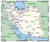
Now, let's talk about the geography of Iran. Iran is a very big country with lots of different landscapes. It has mountains, deserts, forests, and even some coastal areas where the land meets the sea.
In the northern part of Iran, there are tall, beautiful mountains called the Alborz Mountains. They have snow on top of them and you can go skiing there.
In the southwest part of Iran, there is a big desert called the Dasht-e Kavir. It's really hot and dry there, and there's not a lot of plants or animals that can survive.
But even though there are deserts in some parts of Iran, there are also big rivers that run through the country, like the Karun River and the Kura River. And where there are rivers, there are plants and animals that can live and grow.
Iran also has a long coastline along the Persian Gulf and the Gulf of Oman, which makes it a good place for fishermen to catch fish.
So, to summarize, Iran is a big country with different types of landscapes like mountains, deserts, and coastal areas. It has some rivers where plants and animals can live, and there are people who fish along the coast.
Related topics others have asked about: