Geography of Poland

Hey there! Let me explain the geography of Poland to you in a way that you can easily understand, like you are a 5-year-old!
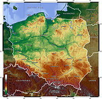
Poland is a country in Europe that is located in the eastern part of the continent. It is bordered by Germany to the west, the Czech Republic and Slovakia to the south, Ukraine and Belarus to the east, and the Baltic Sea, Lithuania, and Russia to the north.
Poland is a pretty big country, about the size of New Mexico in the United States. It is made up of different regions, each with its own unique geography. There are flat plains, rolling hills, and even some mountains in the south. The highest mountain in Poland is called Rysy and it is almost 8,200 feet tall.
Poland also has many rivers, including the Oder, Vistula, and Bug rivers. These rivers are important for transportation and for providing water for the people who live there. The Vistula River is the longest and the most important river in Poland.
The climate in Poland is unique, too. It is mostly cold and cloudy during the winter months, and warm and sunny during the summer months. The country experiences all four seasons, just like we do here in the United States.
Poland is an important country in Europe and has a rich history and culture. I hope this helped you understand a little bit more about the geography of Poland!
Related topics others have asked about:
