Geography of Wales
Wales is a country located in the southwestern part of Great Britain, which is an island in Europe. It is bordered by England to the east and the Atlantic Ocean and the Irish Sea to the west.
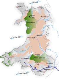
Wales has lots of mountains and hills, which can be tricky to climb but look pretty. Some of the most famous mountains include Snowdon, which is the highest point in Wales, and Mount Tryfan, which is known for its distinctive shape. There are also lots of forests, lakes, rivers, and beaches in Wales.
Wales has a coastline that is over 1,500 kilometers long. Some of the most popular beaches include Rhossili Bay, which is known for its natural beauty and sand dunes, and Tenby, which is surrounded by medieval walls and colorful buildings.
Wales has many cities, towns, and villages, each with their own unique character. The capital city is Cardiff, which is a busy and bustling city with lots of shops, restaurants, and museums. Some other popular cities include Swansea, Newport, and Wrexham.
In Wales, the official language is Welsh, which is a Celtic language that sounds very different from English. Many people in Wales speak both Welsh and English. The culture of Wales is rich and diverse, with lots of traditional music, dance, and food. The most famous Welsh dish is probably Welsh rarebit, which is a type of cheesy toast.
Overall, Wales is a beautiful and interesting country with lots of things to see and do. Whether you like the outdoors or the city life, you're sure to find something you love in Wales.
Related topics others have asked about: