Geographic coordinate system

A geographic coordinate system is like a giant map that helps us find things in the world. Just like how we might use a map to find our way to a park or a friend's house, geographic coordinates help us find specific locations on Earth.
To imagine a geographic coordinate system, think of a giant graph, but instead of just two axes (like the x and y axes in math class), there are three. These three axes are called latitude, longitude, and elevation.
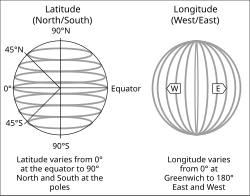
Latitude is like the horizontal lines of a graph, except they run in circles around the Earth. Latitude lines start at the equator (the middle of the Earth) and measure how far north or south something is. The North Pole is at latitude 90 degrees north and the South Pole is at latitude 90 degrees south.
Longitude is like the vertical lines of a graph, except they run up and down the Earth. Longitude lines start at the prime meridian (an imaginary line that runs through Greenwich, England) and measure how far east or west something is. The line of longitude that passes through the prime meridian is at 0 degrees, and it goes up to 180 degrees east and 180 degrees west.
Finally, elevation measures how high up something is above sea level. Sea level is used as the starting point, and elevations go up from there.
So, when someone gives you a location with geographic coordinates, they might say something like "23°N, 91°W, 1000ft" which means the location is 23 degrees north of the equator, 91 degrees west of the prime meridian, and 1000 feet above sea level. With these coordinates, anyone else can find that same location on a map or a GPS device.
Related topics others have asked about:
