Geographic coordinate systems
Geographic coordinate systems help people to know exactly where they are on Earth. Just like your house has a unique address (like 123 Main St.), every spot on Earth has a unique address too. This is because Earth is a big round ball, and we need a special way to find any spot on it.
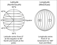
Geographic coordinate systems use lines of longitude and latitude to find any location on Earth. These lines are like a big grid that covers the whole planet. The equator is the most important line of latitude. It's an imaginary line that circles Earth around its middle.
Latitude and longitude are like imaginary lines running from the North to the South Pole and the East to the West. Longitude tells us how far East or West we are from the Prime Meridian, which is a line that goes through Greenwich, England.
Latitude tells us how far North or South we are from the Equator. We can pinpoint a location using coordinates that give us information about both latitude and longitude.
So, if you want to tell someone where you are on Earth, you can give them your coordinates, just like you might give them your house address. This helps people find their way and explore the world in a better way!
Related topics others have asked about: