Grid reference system
Alright kiddo, so imagine you have a big piece of paper and you want to find something on it. But this piece of paper is so big that you don't know where to look. So what do you do? You create a grid!
A grid is like a bunch of boxes or squares that cover the whole paper. And each box has a number or a letter to help you find things more easily. For example, you can say "the toy car is in box B-6" and your friend will know exactly where to look.
Now, imagine that the big piece of paper is actually the Earth and you want to find something on it, like a city or a mountain. That's where the grid reference system comes in handy.
The grid reference system is a way to divide the Earth's surface into smaller parts, just like the boxes on the paper. But instead of letters and numbers, we use latitude and longitude lines.
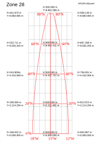
Latitude lines go from east to west and measure how far north or south you are from the Equator, which is the imaginary line that goes around the middle of the Earth. Longitude lines go from north to south and measure how far east or west you are from the Prime Meridian, which is the imaginary line that goes through Greenwich, England.
So, if you want to find a city in the United States, you can use its latitude and longitude coordinates to locate it on a map. For example, New York City is located at 40.7128° N, 74.0060° W. This means it's 40.7128 degrees north of the Equator and 74.0060 degrees west of the Prime Meridian.
By using these coordinates, you can make a grid reference like "New York City is in box 40°N, 74°W". And just like with the paper grid, anyone who knows how to read the coordinates can find exactly where New York City is on the map.
And that's the grid reference system for you! A way to make finding things on a map easier by using latitude and longitude lines to create a grid of boxes.
A grid is like a bunch of boxes or squares that cover the whole paper. And each box has a number or a letter to help you find things more easily. For example, you can say "the toy car is in box B-6" and your friend will know exactly where to look.
Now, imagine that the big piece of paper is actually the Earth and you want to find something on it, like a city or a mountain. That's where the grid reference system comes in handy.
The grid reference system is a way to divide the Earth's surface into smaller parts, just like the boxes on the paper. But instead of letters and numbers, we use latitude and longitude lines.
Latitude lines go from east to west and measure how far north or south you are from the Equator, which is the imaginary line that goes around the middle of the Earth. Longitude lines go from north to south and measure how far east or west you are from the Prime Meridian, which is the imaginary line that goes through Greenwich, England.
So, if you want to find a city in the United States, you can use its latitude and longitude coordinates to locate it on a map. For example, New York City is located at 40.7128° N, 74.0060° W. This means it's 40.7128 degrees north of the Equator and 74.0060 degrees west of the Prime Meridian.
By using these coordinates, you can make a grid reference like "New York City is in box 40°N, 74°W". And just like with the paper grid, anyone who knows how to read the coordinates can find exactly where New York City is on the map.
And that's the grid reference system for you! A way to make finding things on a map easier by using latitude and longitude lines to create a grid of boxes.
Related topics others have asked about: