Local-area augmentation system

The Local-Area Augmentation System (LAAS) is a special system that helps airplanes and other vehicles navigate safely through the skies. Imagine you are driving a car and you have a map to help you know where you are going. The LAAS is like a special map for airplanes.
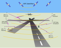
The LAAS uses many special devices called GPS satellites that are up in space. These satellites constantly send signals to the ground, which helps airplanes and other vehicles know their exact location. It's like having a superpower that tells you where you are at all times!
But sometimes, just knowing where you are is not enough. The LAAS also makes sure that airplanes stay safe by giving them more information. It helps to make sure the airplanes get to where they want to go without crashing or getting lost.
The LAAS works by having special ground-based stations that communicate with the GPS satellites. These stations are like special friends that help the satellites know where the airplanes are. They use special antennas to send and receive signals.
When an airplane wants to know where it is and where it should go next, it talks to the LAAS. The LAAS looks at the signals from the GPS satellites and the signals from the ground-based stations. With all of this information, it can calculate the airplane's exact position and give it directions on where to go.
The LAAS is also very good at detecting any errors or problems that might happen. It can tell if the GPS signals are not very accurate, and it can quickly fix those errors. It's like having a superhero that can fix things that go wrong!
Overall, the Local-Area Augmentation System is a special system that uses GPS satellites and ground-based stations to help airplanes and other vehicles know where they are and where to go. It keeps them safe and helps them avoid any problems that could happen. So, the next time you see an airplane in the sky, remember that the LAAS is helping it fly safely!
Related topics others have asked about:
Acronyms and abbreviations in avionics,
Autoland,
Differential GPS,
European Geostationary Navigation Overlay Service,
GPS and Geo Augmented Navigation,
Global Positioning System,
Instrument landing system,
Joint Precision Approach and Landing System,
Precision approach,
Wide Area Augmentation System
