Mercator projection
Hey there! Do you know what a map is? A map is a picture that shows us where different places are on the Earth. A Mercator projection is one type of map that is often used to show the whole world on a flat piece of paper.
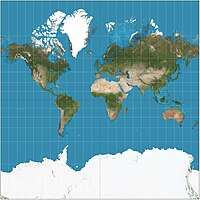
Now, usually, the Earth is a big round ball, but when we want to make a map of it, we have to "flatten" it out onto a piece of paper, right? That's where the Mercator projection comes in.
The Mercator projection is named after a person named Gerardus Mercator who drew this type of map a long time ago. This kind of map shows the Earth as a rectangle, like a big sheet of paper, and it's usually the map you see in classrooms around the world.
Now, what's special about the Mercator projection is that it shows the world as it would look from high up in the sky or far away in space. So, it's like looking down on the Earth. This makes it good for navigation and helps people figure out how to get from one place to another.
But there is a problem with the Mercator projection too. The map makes the places that are close to the North and South Poles look much bigger than they actually are. This is because the map "stretches" these areas out since it's a rectangle. This can sometimes make people think that these places are more important or have more land than they actually do.
So, to sum it up, the Mercator projection is a famous type of map that helps us navigate and see the world from above, but it can make some places look bigger than they actually are.
Related topics others have asked about: