Topographic map
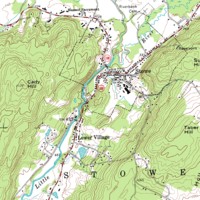
A topographic map is a special type of map that shows the physical features of an area, like mountains, valleys, lakes, and rivers. It looks like a bunch of squiggly lines and shapes, but it helps people understand what the land looks like in a certain place.
Think of it like a picture of a cake, but instead of showing the yummy frosting and decorations, it shows how the cake is shaped and where it goes up and down. Just like with a cake, a topographic map helps people see where things are higher and where things are lower.
But instead of using colors like in a regular map, a topographic map shows different heights with lines. These lines are called contour lines, and they connect all the places that are the same height. The closer together the contour lines are, the steeper the land is. Think of it like counting how many stairs you need to climb up a hill - the more stairs you need, the steeper the hill is.
Topographic maps are important for all sorts of things like hiking, camping, and building roads. They help people plan out their routes and understand what the area they are in looks like. So, the next time you see a squiggly line-filled map, remember that it's a topographic map and shows the shape of the land!
Related topics others have asked about: