Topography
Topography is like the land's face! Everywhere you stand has a "face". You know how people have different faces like round, square, or long? Well, the ground you walk on can have different faces too. It can be flat like a stick or have hills and valleys like the rollercoaster you rode at the fair.
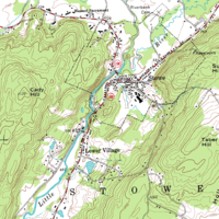
Topography is like a map of those different faces. It shows you where the hills, valleys, mountains, and plains are in a specific area. Think of it like a big coloring book picture that shows all the little bumps and dips in the land.
When you see a topography map, you can see how high the ground is and how steep it is going up or down. The lines on the map show you the elevation of the land, with the closer lines showing areas that are higher and the farther apart lines showing areas that are lower.
Sometimes, the faces of the land can be really important. Imagine if you were trying to build a house, but the ground was on a slope that was too steep. That wouldn't be very safe, would it? Or if you were trying to grow crops, you would need to know if the land was flat enough to plant them. Topography helps us understand what we can and can't do in certain areas, and it helps us make better decisions about how to use the land.
Related topics others have asked about: