Horizontal coordinate system
Imagine you are standing outside in a big open field, and you want to describe where things are in the sky like the sun, moon, or stars. The horizontal coordinate system is a way to do that.
Think of it like a game of "hot and cold." You start by standing in the middle of the field, and everything you want to describe is somewhere out in front of you in the sky.
First, you need to know which way is north, south, east, and west. This is like knowing which way to point when someone says "go left." You can figure this out by using a compass or by looking for landmarks like a tall building or a mountain range.
Now that you know which way is which, you can describe where things are in the sky using two main measurements: altitude and azimuth.
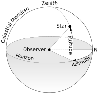
Altitude is like how high up something is. Imagine a ladder leaning against the sky, and you need to say which rung the thing is on. Altitude is measured in degrees, with 0 degrees being right at the horizon (where the earth meets the sky) and 90 degrees being straight up overhead.
Azimuth is like which direction something is in. Imagine you are playing a game of "Marco Polo" in the sky, and you need to say which way to go to get closer to the thing you're looking for. Azimuth is measured in degrees, with 0 degrees being due north, 90 degrees being due east, and so on.
So, to describe where something is in the sky using the horizontal coordinate system, you need to say its altitude and azimuth. For example, you might say that the sun is at an altitude of 30 degrees and an azimuth of 180 degrees (meaning it is due south).
This system is useful for identifying objects in the sky and for tracking them as they move across the sky throughout the day and night. It's also handy for astronomers who study the stars and planets, as they can use this system to pinpoint the exact location of celestial objects in the sky.
Think of it like a game of "hot and cold." You start by standing in the middle of the field, and everything you want to describe is somewhere out in front of you in the sky.
First, you need to know which way is north, south, east, and west. This is like knowing which way to point when someone says "go left." You can figure this out by using a compass or by looking for landmarks like a tall building or a mountain range.
Now that you know which way is which, you can describe where things are in the sky using two main measurements: altitude and azimuth.
Altitude is like how high up something is. Imagine a ladder leaning against the sky, and you need to say which rung the thing is on. Altitude is measured in degrees, with 0 degrees being right at the horizon (where the earth meets the sky) and 90 degrees being straight up overhead.
Azimuth is like which direction something is in. Imagine you are playing a game of "Marco Polo" in the sky, and you need to say which way to go to get closer to the thing you're looking for. Azimuth is measured in degrees, with 0 degrees being due north, 90 degrees being due east, and so on.
So, to describe where something is in the sky using the horizontal coordinate system, you need to say its altitude and azimuth. For example, you might say that the sun is at an altitude of 30 degrees and an azimuth of 180 degrees (meaning it is due south).
This system is useful for identifying objects in the sky and for tracking them as they move across the sky throughout the day and night. It's also handy for astronomers who study the stars and planets, as they can use this system to pinpoint the exact location of celestial objects in the sky.
Related topics others have asked about: