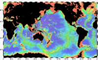
Seafloor mapping

Seafloor mapping is like making a big map of the bottom of the ocean. Just like how we have maps of the roads and buildings on land, scientists use special tools that measure the depth and shape of the seafloor to make maps of what it looks like underwater.
To make these maps, scientists use things called sonar devices. Sonar works like a type of echo. A ship sends out sound waves down into the water, and when the waves hit something, like the seafloor or a shipwreck, they bounce back up to the ship. The sonar device then records how long it took for the sound waves to come back up, and from that, scientists can calculate how deep the water is or the shape of things underwater.
Scientists use these maps to help them learn more about the ocean, like where different kinds of animals live, where to put things like wind turbines or underwater cables, and even to find shipwrecks! Seafloor mapping helps us better understand our oceans and all the amazing things that call it home.
Related topics others have asked about:
